The PCC secured funding from the Government’s Safer Streets Fund, which earmarked £25m for increased detection and prevention measures across England and Wales to target acquisitive crime.
Leicestershire was awarded £549,998 for an area in Westcotes that includes Narborough Road and neighbouring streets; £549,999 for the Warwick Way and Dishley estates in Loughborough; and £418,309 for Braunstone Frith. The maximum available for each area is £550k.
The funding was invested in proactive crime prevention and detection tools including CCTV, enhanced street lighting, graffiti removal and free home security improvements for residents in qualifying areas.
It also funded the appointment of community safety coordinators across all three communities who will worked with community groups and residents to deliver crime prevention advice and support.
The outline bids for the three areas were as follows:
Westcotes bid outline
The overall approach for the area was to take a strong community approach to ensure that the community were fully on board. On the key trunk roads of the area were ANPR/CCTV fixed cameras on existing lamp posts so as to be able to understand who was going in and out of the area (intelligence and dis-incentive), re-deployable CCTV (pan, tilt, zoom) within the estate at key locations to further deter/gather intelligence – moved every 8 weeks to give coverage. Target hardening was made available to all households via 24/7 Locks who undertook property/vulnerability assessments and fitted appropriate items. Community assets were built through Neighbourhood Watch, the community safety officer and DMU student volunteers who also distributed property marking kits and received training. On a more targeted basis gating was provided (on a per property basis) to those properties that were particularly vulnerable through such access routes and graffiti was removed to improve the environment.
A map of the relevant area can be found below (please click on the map for a larger image)
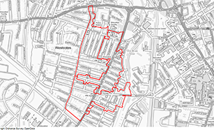
For a pdf version of this map - please click HERE
Warwick Way/Dishley Estates and Thorpe Acre bid outline
The overall approach for the area was to take a strong community approach to ensure that the community were fully on board. On key trunk roads within the area were ANPRCCTV fixed cameras on existing lampposts so as to be able to understand who was going in and out of the area (intelligence and dis-incentive), CCTV (pan, tilt, zoom) within the estate at key locations to further deter/gather intelligence. Target hardening was made available to all households via 24/7 Locks who undertook a property/vulnerability assessment and fitted appropriate items. Community assets were built through Charnwood Watch and the Warwick Way Community group. On a more targeted basis Charnwood Borough Council would be installing 16 enhanced communal front access doors at high risk locations.
A map of the relevant area can be found below (please click on the map for a larger image
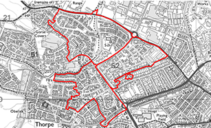
For a pdf version of this map - please click HERE
Braunstone Frith bid outline
The overall approach for the area was to take a strong community approach to ensure that the community were fully on board. At the top and bottom of the part of the ring-road abutting the bid area ANPR/CCTV fixed cameras were fitted on existing lampposts so as to be able to understand who was going in and out of the area (intelligence and dis-incentive), re-deployable CCTV (pan, tilt, zoom) within the estate at key locations to further deter/gather intelligence – moved every 8 weeks to give coverage. Target hardening will was made available to all households via 24/7 Locks who undertook a property/vulnerability assessment and fitted appropriate items. Community assets were built through Neighbourhood Watch, the community safety officer and DMU student volunteers who also distributed property marking kits. On a more targeted basis we considered whether there were specific things that could be done in a couple of the key hotspots. In particular gating was provided (on a per property basis) to those properties that were particularly vulnerable and graffiti was removed to improve the environment.
A map of the relevant area can be found below (please click on the map for a larger image)
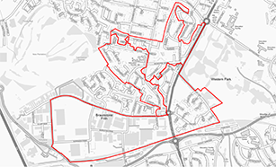
For a pdf version of this map - please click HERE
To view the press release, please click HERE
Please note: The boundaries used may seem strange but they are in fact pre-existing boundaries used for statistical purposes nationally and the Home Office have required us to use them so that they can understand the long term benefits of such an investment.

Security fittings and advice via 24/7 locks will be available in the above three areas. If you are not sure whether you live in the area covered by this service you should have received a leaflet through your door. If you are still not sure please do not hesitate to CONTACT US.
We also have some helpful security videos which can be viewed below: